
During the middle of February, a split in the Polar Vortex allowed cold air to plunge southward and warm air to surge northward to the North Pole.
The Polar Vortex is a storm high in the atmosphere that helps to keep frigid air locked up in the Arctic.
Occasionally, this storm gets distorted, moves southward and can break apart into lobes which allow cold air to press toward mid-latitudes. However, the cold air usually only pushes southward into one or two continents or parts of continents.
During the middle of February, the main vortex of frigid air took aim at Europe with a smaller vortex affecting part of western North America, including the western United States.

"The split of the Polar Vortex was brought on by rapid warming in the upper part of the atmosphere (known as the stratosphere) over the North Pole a couple of weeks earlier," according to AccuWeather Lead Long-Range Meteorologist Paul Pastelok.
This event is called sudden stratospheric warming (SSW).
The normal west-to-east movement of storm systems was altered.
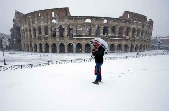
The pattern brought cold and snowy conditions to much of Europe. The same pattern sent chilly conditions, then storms with rain and snow southward into the western U.S.
An atmospheric roadblock developed around much of the Northern Hemisphere in general.
With the routine forward motion stalled, warm air was able to push toward the Arctic Circle and cold air was able to push southward toward the Mediterranean Sea and California.
During the warm surge, temperatures climbed well above the freezing mark (32 degrees Fahrenheit) during the last week of February. Within a few days of the occurrence, it was substantially colder in London and Rome, where temperatures dipped into the 20s and snow fell.
During February, average temperatures for the North Pole are near to below zero while average high temperatures are in the 40s in London and the 50s in Rome.
"Topsy-turvy temperatures in the Arctic versus the mid-latitudes occur every year to some extent," Pastelok said. "Ones that approach this magnitude occur less often, about every two to three years in recent decades."
The challenge with the end result of SSW's is there is no way to tell for sure which continent the surge of cold air and associated displacement of the Polar Vortex will go until it is almost at the doorstep.
"We expect the Arctic region to cool significantly as the Polar Vortex strengthens and returns to its more routine position near the North Pole by the middle of March," Pastelok said.

More of a west-to-east flow of air is likely to resume gradually during March in general.
Pastelok cautioned that there will still be a slowdown and strengthening of storms in the northeastern United States into the middle of March.
"There is potential for one or two more storms to cause damage and major disruptions in the Northeast through mid-March," Pastelok said.
There is a chance of another SSW and a displacement of the Polar Vortex into April, but most likely less impact would be felt.
"The role the position of the Polar Vortex plays during the spring diminishes over time, on average," according to AccuWeather Meteorologist Max Vido.
The strengthening sun plays an increasing role beginning at the mid-latitudes and expands northward as the spring progresses.
AccuWeather, Full Article