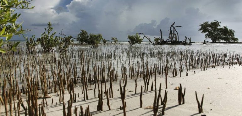
Last spring, a team of NASA scientists looking at South Florida's dwindling wetlands flew over the Everglades hoping to use aerial 3D imaging and data from the planet's longest orbiting satellites to plot changes. Then Irma hit.
In a matter of hours, about 40 percent of the mangroves were damaged or flattened.
The massive toll from the storm was not all that surprising. Irma was as wide as the state and slammed the Lower Keys as a Cat 4 before barreling north and making a second landfall near Marco Island as a Cat 3. But what was baffling was how little of the forest, perfectly evolved to endure hurricanes, had recovered when scientists retraced their flight three months later.
"What took me aback was not so much the immediate damage, because you expect to see that. But some areas are really struggling to return," said Lola Fatoyinbo, a forest ecologist and the project's principle investigator at NASA's Goddard Space Flight Center in Maryland. "It was really, really hammered. There was basically just a bunch of stumps left, and they don’t seem to be recovering."

Those two flights now provide a perfect opportunity for the team to study change, at a dramatic scale. More importantly, the data collected allows them to assess how increasing threats from climate change in the swampy mangroves, which can be impossibly difficult to measure, will factor into forests rebounding from hurricanes. Will areas already battered by saltwater intrusion struggle more? Will there be a cascading effect on neighboring marshes already slammed by decades of flood control?
"They're used to getting hit," Fatoyinbo said. "But now that they have these other conditions, are they still able to recover?"
NASA scientists who flew over the Everglades, Florida Bay and the 10,000 Islands before Hurricane Irma returned three months after the storm and found up to 40 percent of mangroves damaged.
About half the planet's mangroves have disappeared. But despite their critical job of storing huge amounts of carbon, protecting coasts and providing nurseries for marine life, they remain largely mysterious. Research can be time-consuming and brutal, with a hike across just a few acres of knee-busting prop roots and shoe-sucking muck taking hours. For forest ecologists, deploying a laser imaging technology called lidar, was like getting a jet pack.
First used to measure clouds in the 1960s, lidar has been used to map the surface of the moon, track pollution and calibrate wind farms. Radiohead used lidar to film its "House of Cards" video. And it has revolutionized forest ecology, allowing scientists, for example, to calculate the density of a canopy by looking at individual leaves and limbs, or determine the height of the forest floor.
"It's like looking at a map vs. a 3D model," Fatoyinbo said. "We can essentially see through the forest."
NASA first flew over Florida shooting lidar images in 2015 and returned for two additional flights in 2017. The project was originally intended to look at damage from decades of flood control, and increasing threats from climate change, on marshes that have begun to switch from freshwater to saltwater. The project was also meant to assist Everglades scientists working on a long-term ecological research project started in 2000 and led by Florida International University.
"We want to know how fast this transition is happening," said NASA researcher David Lagomasino, who started the work while studying at FIU. "We can estimate where the key habitats are that are most vulnerable to hurricanes and saltwater intrusion."
In addition to lidar, NASA's specially developed instrument also collects thermal imaging and high resolution imaging. In April, the team flew across 500 square miles, from the Keys, across Florida Bay and up the west coast over the 10,000 Islands to Port Charlotte. Three months after Irma, they retraced their steps.
Comparisons of the two flights revealed damage to about 200 square miles of the mangroves, from snapped branches to uprooted trees. In 20 percent of the hardest-hit areas, the forest canopy was shortened by three to five feet.
Another team made a similar flight over the tropical forests of Puerto Rico before Irma and Maria and plans to return this week to collect images for comparison.
By comparing the before and after, researchers can pinpoint vulnerable areas already stressed by saltwater intrusion or nearby coastal development. They can then compare that to images taken from the Landsat satellites, which have been circling the globe for the last 30 years, to look at damage and recovery from past hurricanes and track whether forest bounces back more slowly, or not at all.

The 3D imaging could also provide a window into how the forest cycles carbon, a key weapon to fight global warming, Fatoyinbo said. Scientists consider the Everglades mangroves the Amazon of the U.S., capable of sucking up tons of carbon each year and helping cool the planet.
One study put the value of the storage at between $2 billion and $3.4 billion. But when a hurricane blows through, it's not clear whether the mangroves hold on to the carbon, or spit it back out. A lot of the carbon is stored in the forest floor, but carbon also gets stored in branches and leaves.
"One of the questions we’re trying to address is whether we can measure how much debris is on the ground, because that will tell us how much is stored in the soil as opposed to being exported into the ocean," she said.
And quantifying damage could ultimately allow them to quantify recovery, she added.
"What percentage of the ecosystem or the mangrove’s canopy is damaged or blown away and where does it go?" she said. "Does this result in widespread die-off and loss of carbon or does it get recycled? Maybe it just stays there, and this is something we can actually map."
Source: Miami Herald, Full Article