
San Diego scientists who are interested in rising sea levels recently spent a chunk of time in the coastal community of Imperial Beach. They were there to see the impact of a storm swell on top of an astronomical high tide.
The low-lying city is nearly surrounded by water and the community faces real and immediate challenges from a changing climate.
“There’s not much we can do once the ocean reaches a certain level and the surf a certain height. There’s not much we can do,” said Imperial Beach Mayor Serge Dedina.
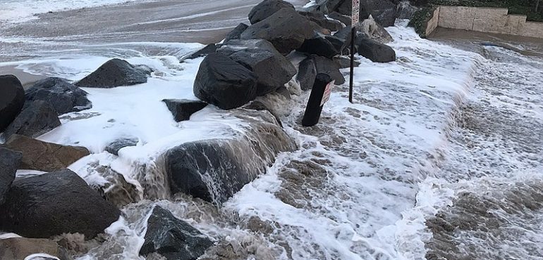
Recent high tides and an active storm cell were working together to blast coastal barriers designed to keep the ocean at bay. The large rocks that formed the barrier didn’t always succeed. The storm-fueled waves regularly washed over the coastal reinforcements.
Public safety officials did what they could to protect people living here. They got out, placed signs where flooding typically occurs and made sure people stayed out of range of the waves.
After the water rolls over the seawall and fills the adjacent Tijuana River Estuary, the overflow gets trapped on city streets.
Mark Merrifield of the the Scripps Institution of Oceanography said the flooding will happen more often.
“So we know sea level is going up, but if you add on these wave events, what does that look like?” said Merrifield.
He runs the Center for Climate Change Impacts and Adaptation. Merrifield said Imperial Beach faces a unique challenge in the face of higher ocean levels, and he wants to understand all the forces at play.
“The sea level is so high in the estuary, where it normally would drain, that is just backing up the water. So that effect is also important to measure and document. And, in a way, this is almost a natural laboratory for that sort of thing,” Merrifield said.
But the situation in the ocean is what’s most interesting.
Researchers know a lot about local tides and they have pretty good data on storm-driven wave events, but there’s a gap in their knowledge when those things happen together.
“Trying to get the waves from offshore to onshore during these kinds of energetic wave events, there’s not a lot of data. That’s why this data is so important to get the combination of … to really map out one of these events in detail,” Merrifield said.
The event was being tracked from many perspectives.
There was an offshore wave buoy, buried monitors in the sand and a drone flying overhead. On a second-floor condo balcony on Seacoast Drive researchers used a machine that takes specific measurements of the roiled surf by using pulses of light to calculate the range of nearby objects.
“This distance here is about 150 feet across and this is a two-dimensional view looking straight out at the ocean,” said Lucien Perry, a marine technician.
The lidar equipment is sophisticated enough that it can track and record many individual waves. In addition, it can draw a three-dimensional picture of the survey area.
“This grey line here is the line that we were just looking at in the real-time view. And we pull it into a three-dimensional view. And these are the waves coming in and the beach,” Perry said.
All of this information will help researchers build better predictive models about events that will likely occur more often as sea levels rise.
Knowing more is critical for Imperial Beach Mayor Dedina, who is concerned about planning for the future.
“What are we going to do with our sewer pump stations? What are we going to do with our roads? What are we going to do with our electrical outlets? We’re working with SDG&E on that. We have a school that’s on the bayfront. And then how are we going to deal with actually mitigating rising seas and increased erosion?” Dedina asked.
Rising sea levels are not something the city can ignore because the low-lying community has an ocean, an estuary and San Diego Bay on three sides.
“We’re going to have to face some tough choices in what we do to address protecting our public beach and public access. So we’re looking at natural solutions and then really protecting our infrastructure,” Dedina said.
Public property is the city’s primary concern, according to Dedina, but private property owners in the city also have some decisions to make as water pushes against the city’s boundaries.
Source: KPBS, Full Article