
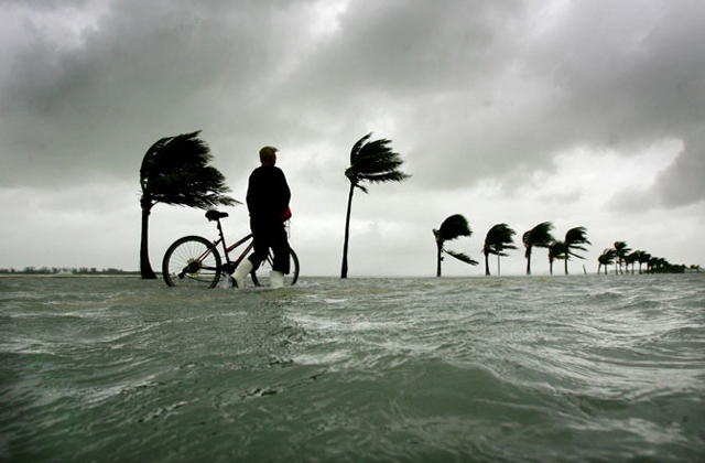
Every fall when the king tides roll in, the most obvious sign of climate change asserts itself in South Florida: flooding everywhere, from submerged roads in Miami to waves washing across neighborhoods in the Keys to swamped docks and yards in Fort Lauderdale’s canal-side homes.
But beyond the flooding, a more insidious problem is at work. South Florida’s water is changing.
Under climate change projections, beaches and bays that draw tourists and anglers and help fuel a booming real estate industry could grow saltier and more polluted.
Underground saltwater is already spoiling the aquifer and moving closer to drinking water supplies for six million residents. If the Everglades dries up more than it already has, peat soil that provides the scaffolding for an entire ecosystem could collapse. This summer, a dangerous fog of yellow sulfur appeared in Florida Bay, triggered by a regional drought that under climate change projections would occur more often. And just this month, scientists reported that a massive coral bleaching event in the Pacific triggered by rising ocean temperatures had spread to the Caribbean.
In its simplest terms, climate change is threatening the state’s most vital resource: water.
It’s really mind boggling to witness it happening that fast, in less than a human lifetime.
Chris Bergh, South Florida conservation director for the Nature Conservancy
“It’s really mind boggling to witness it happening that fast, in less than a human lifetime,” said Chris Bergh, South Florida conservation director for the Nature Conservancy. “No question we’ll adapt. The question is when and how much it will cost.”
And whether the increasingly stressed environment can tolerate our presence.
Last year, when Miami Beach turned on four new pumps — the first of dozens planned to keep the city dry — FIU hydrologist Henry Briceno sent a team to sample water in Biscayne Bay to see whether the mass flushing had any effect. Samples revealed a sixfold increase in pollution in some parts of the bay. Phosphorus, nitrogen and other agents were being carried by groundwater pushed up through soil loaded with fertilizers and dog poop and onto dirty streets. Pumps then carried the water, filtered for debris like plastic bottles but otherwise untreated, into the bay.
“People think that when they see the city flooded by seawater, it’s water from the beach. It’s not,” he said. “Those waters are problematic. They are not good.”
Briceno’s team will be back out this week when another king tide is forecast, gathering water samples that will help clear up the still murky impacts. Miami-Dade County and the Beach are still working out a plan to monitor environmental impacts.
6 to 10 inches New sea rise projections for 2030 released this month by the four-county Southeast Florida Regional Compact
Beyond urban Miami, scientists say inshore waters are also changing. Since 1996, the National Oceanic and Atmospheric Administration has monitored water about 1,600 feet from shore around the Florida Keys for signs of waste that could pollute fragile marine areas. As expected, the level of nutrients has been high, creating what scientists call a halo zone.
In the short term, the high tides may actually help flush damaging nutrients from nearshore waters, said Billy Causey, NOAA’s National Marine Sanctuaries regional director. But that’s a temporary boon more than offset by rising ocean temperatures. With high temps increasing salinity and lowering oxygen, fewer nutrients can cause a lot more damage, particularly to coral.
“We don’t give water temperatures enough blame for what’s happening to our system,” he said. “It’s one of the real impacts on coral reef ecosystems.”
CREEPING IN
Sea rise also will increasingly challenge the region’s massive network of flood control structures that play a key role in protecting South Florida’s precious fresh water supply, much of it in the underground Biscayne Aquifer.
Since 1955, the U.S. Geological Survey has tracked the westward creep of underground saltwater. Because South Florida’s drinking water supply sits above heavier saltwater in pocked limestone — imagine a hardened sponge — water can easily flow back and forth. To keep saltwater out, South Florida water managers maintain canals higher than the ocean — creating a wall of water — to separate fresh water and sea water with a system of massive coastal gates.
As sea level inches up, keeping out that salt water will become more challenging because canals can be raised only so far without crippling their ability to control flooding. The drainage capacity of the entire system, which relies on pumps and gravity to slough storm water into the bay, is also slowly decreasing as sea levels rise.
The last time the South Florida Water Management District assessed that risk was in 2009. According to a document provided by the district, 20 flood control structures were expected to fail with as little as a half foot rise in sea level, the levels now projected for the region in 15 years. Another nine were in danger if seas rise between a half foot and five feet.
The inland creep of saltwater has already put some wellfields in Broward County out of service. The county has stopped using two southern wellfields, said Mike Zygnerski, a hydrologist with the county’s water resources assessment section. Deerfield Beach closed its eastern wells. Hallandale no longer uses six of its eight wells and Dania moved a wellfield west. Hollywood only uses two of its three wellfields, he said.
Imagine what will happen with a higher sea level.
It’s physics. The higher the water level, the easier it is for wellfields to be compromised.
Broward County Water Resources hydrologist Mike Zygnerski
“It’s physics. The higher the water level, the easier it is for wellfields to be compromised,” Zygnerski said.
With most of its wellfields located farther west, Miami-Dade County is on safer ground, said Virginia Walsh, the county’s chief hydrogeologist. But that’s not to say officials aren’t worried. Four new wells are now being installed to monitor the salt front, Walsh said. Staff is also closely watching the south end of the county, where in just 10 years the front has moved nearly two miles closer to a wellfield that is the only source of freshwater in the Keys. A handful of county wells that use the field are being phased out, Walsh said.
When the county modeled the progress of the front last year, using old sea rise projections of nine to 24 inches by 2060, scientists found wellfields “in pretty good shape,” Walsh said. Whether that holds with new projections now being fed into the models remains to be seen.
Modeling groundwater flow through the Biscayne aquifer, one of the most porous on the planet, can be complicated and only as good as the information fed into it, said Dorothy Sifuentes, a supervisory hydrologist with USGS’s Caribbean-Florida Water Science Center in Davie. The limestone rock that forms the aquifer is filled with holes in limitless sizes. Saltwater can dissolve the limestone, which could open new conduits that allow the salt front to move even faster and farther inland. And if oceans become more acidic, the question becomes: Could limestone erode faster?
IF THE PEAT GOES
In the Everglades, scientists are just starting to understand what could happen if the freshwater marshes get saltier. At the foundation of the marsh is a boggy soil called peat, made of decomposed sawgrass and other plants held together by plant roots and very little actual soil. If salt gets into the peat, it can act like a detergent and loosen the soil to break apart the peat, said University of Florida biogeochemist Todd Osborne.
“It doesn’t dissolve, it just becomes more oozy,” he said.
Peat also forms very slowly, at about one millimeter a year. A strong storm surge could potentially wipe out a foot of peat. “That’s 250 years of soil-building lost in a matter of days,” he said.
Up until now, most peat loss — what scientists call subsidence — has been attributed to flood controls that drained large parts of the upper Everglades to make way for farming. But if enough saltwater creeps into the lower range, Florida’s marshy tip could disappear.
While loss of habitat would obviously wreak havoc on the ecosystem, scientists are considering another more ominous problem in the climate change equation. The spongy soil traps huge amounts of carbon. If seas overtake the marshes, carbon stashed in the peat would move into the atmosphere’s worsening carbon loop. The carbon also carries nutrients that could make warming oceans more vulnerable to toxic algae blooms. Early signs of an algae bloom have already been spotted in Florida Bay, where a summer drought helped kill at least 13 square miles of seagrass and left a cloud of yellow sulfur that scientists fear could spread to 75 square miles.
It’s a double bad for Florida Bay and for us and the environment
University of Florida biogeochemist Todd Osborne
“It’s a double bad for Florida Bay and for us and the environment,” Osborne said. “It’s a one-two punch.”
‘ON THE VERGE’
If it were only water on the streets and in canals that needed to be pumped, addressing climate change in South Florida might be easier. But there are more complicated problems — with trickier solutions that involve policy as much as science — that are still being understood by scientists.
At Turkey Point, cooling canals used to keep Florida Power & Light’s two nuclear reactors chugging have been getting warmer, helping fuel a massive algae bloom that makes it hard for water to cool and do its job. The canals are contributing to an underground plume of saltwater, which led Miami-Dade County, the city of Miami and environmental groups to sue to force the utility to control the plume. Biscayne National Park officials also fear the plume may be making the bay saltier. Last month, the utility proposed using injection wells to pump escaping canal water deep beneath the Biscayne aquifer.
Rising global temperatures also mean South Florida could see 20 percent less annual rainfall. Less rain means more droughts. For Florida Bay, which depends heavily on rainfall to help freshen the bay’s mini basins, that could increase the frequency of seagrass die-offs. And if grasses die, scientists fear the return of the kind of slimy algae bloom that sickened the bay for years after a 1992 event.
“I’m concerned we’re on the verge of it happening again,” Causey said.
Biscayne Bay will also face challenges. Miami-Dade County has been sampling water at 87 spots around the bay for the last 37 years. Scientists look for an array of things, but pay particular attention to the two chemicals that trigger algae blooms, nitrogen and phosphorus, and signs of fecal matter. Overall the bay is healthier than years past because of tougher regulations, said Jamie Monty, who oversees water sampling. But for several years now, an algae bloom has persisted in the central part of the bay between Dinner Key and the Coral Gables Waterway, she said.
Fecal matter also tends to increase during wet, summer months when more stormwater washes into the bay, she said. And that could spell trouble if seas rise and more streets are flooded, a likely scenario under the latest sea rise projections.
Just this month, the Southeast Florida Regional Compact — the four-county partnership formed to address climate change — doubled the rise of sea level expected in the next 15 years to between six and 10 inches. By 2060, that number could rise as high as 26 inches and more than double that, to 61 inches, by 2100.
Predictions are even more dire in a study that appeared earlier this month in the peer reviewed journal Proceedings of the National Academy of Sciences by Princeton ecologist Benjamin Strauss. By mapping out unavoidable sea level rise — the levels already projected regardless of greenhouse gas reductions — he predicts 414 cities across the U.S. will be underwater by 2100. Of those, Florida stands to lose the most, with 40 percent of its population affected by rising seas.
“We’re already seeing changes in our weather patterns. We’re seeing some of the most massive organics on the planet — coral reefs — around the globe affected in a very predictable pattern. We can predict it two weeks out,” Causey said. “That tells you something. That makes a statement that this is real.”
MAKING A PLAN
How the region addresses these problems remains to be seen.
Miami-Dade County officials have long incorporated changes in tidal flooding into infrastructure plans, but are not ready to buy into online mapping tools that show huge swaths of the county underwater, depicting with grim effect flooding in tony parts of Coral Gables, fast-building Doral and Miami Springs.
“Any forecasts for higher tidal elevations, sea level rise if you want to call it that, but it’s just tidal elevation, is being put into the current master plan modeling,” said Marina Blanco-Pape, director of stormwater planning for the county.
Blanco-Pape said the models oversimplify and amplify problems, and she predicts most of the inundation will be confined to the coast and uninhabited southern reaches.
“The county in the developed areas is not just a big bathtub that you put water in and the level rises,” she said.
With projections shifting and sometimes uncertain, the county plans on sticking with numbers adopted by the compact and adjusting projects based on their location and their use.
“We’re constantly going to be changing what we do based on new information. And we can’t plan now for 2100,” said Nicole Hefty, chief of the county’s sustainability office. “It’s going to be a very stepwise process for the rest of our time here in the county. This is the new way we’re going to be doing things.”
In Monroe County, officials holding workshops with residents to talk about sea rise got caught off-guard by the September king tide, which triggered heavy flooding all along the island chain and left parts of Key Largo in knee-deep water for more than two weeks. Furious residents are wondering why they can’t have Miami Beach-style pumps.
“It’s not a simple matter. Remember we’re an island and when you elevate a road it doesn’t necessarily solve your problems,” said Sustainability Chief Rhonda Haag. “Are we going to have to look at different ways [for people] to get to their houses? Are they going to have to use skiffs to get to the house? We don’t know.”
That is not the answer Frank Garces was looking for.
“That’s insane,” said Garces, a Miami native, who moved into a new house with his wife four months ago with no warning about flooding risks. After being swamped for a week, Garces rented a truck for his wife to avoid damaging her 2013 Mercedes-Benz sedan, and then, tired of seeing trash cans toppled by waves and garbage tangled in mangroves, he started a petition to get the county to fix the flooding. His wife, an attorney, is looking into a class-action lawsuit against the county on behalf of residents, he said.
“They can’t reasonably turn the Keys into the United States of Venice,” he said. “I’m sure there’s no easy solution or else it would have been done by now, but certainly smarter people than me can sit down and figure things out.”
